It was more than a year after my last visit with our Photography Club to Mahabaleshwar. Hence, this was in a way much awaited.
We started off by 7.30 am. Bus came about an hour late, as usual. We took the Sinhagad Road - Donje Phata - Paabe Ghat Road, the one we took in our Rajgad trek last month.
After Paabe Ghat you come across a "T"-Joint (with Nasarapur-Velhe Road). Last month for Rajgad we had taken Left. Now for Velhe, Fort Torana (तोरणा) and Madhe Ghat we took Right. As you move ahead, you can see the mighty Torana on your left.
A little ahead there is a left turn towards Velhe - a small town which is the base village for Torana. Along the base of the fort take a right turn by the foothill. Encircling the fort the road goes at the back via Gunjawani (गुन्जवणी) Dam - a picturesque location. One might pass on the photo below as taken somewhere in Europe. Coordinates: 18° 17' 52.63"N, 73° 37' 27.94"E.
We had our breakfast and tea here. We had brought it from Pune itself. After about half-an-hour's break, we moved ahead.
There is a place by the name Kelaad (केळाद). Here there is a T-joint again. Take Right for Madhe Ghat (small sign board is available).
The road goes over a bridge and ends ahead. Tar road stops here. Some rocky and muddy patch is seen ascending straight upwards. A 2-wheeler can still go up, but its better to park a car or a bus here and start walking.
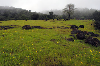
After about half-a-km walk comes small plateau (flat area might remind you of the table land at Panchgani). It was covered with lush greenery with yellow flowers of the season. Clouds were moving around the field creating misty environment. The plateau ends with a deep valley. What you see below is the Konkan region of Maharashtra.
Coordinates: 18° 12' 4.28"N, 73° 34' 39.72"E.


This is the Madhe (मढे) Ghat - a relatively unknown place located like a stone's throw distance towards south-west of Pune in the vicinity of Torna Fort.
This place has a unique reference in our history. One of the greatest warriors under Shivaji, Narveer Tanaji Malusare (नरवीर तनाजी मालूसरे) laid down his life in the battle of Sinhagad (सिंहगड़), a fort not very far from here. He belonged to Konkan. His body was taken for last rites in his native village Umarathe near Poladpur through this route. Hence the name - Madha (मढ़) in Marathi means "dead body".
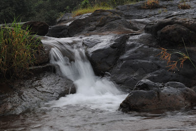
There was this stream of water coming from somewhere and falling down in the valley. We were not able to capture anything of it. We took some shots here.

However what we saw from other side of the plateau, this was not just any stream of water. It was forming an awesome waterfall more than 50-60 feet in height.
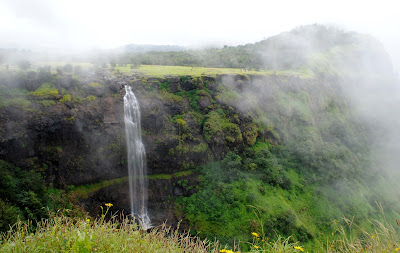

The day was very cloudy. It tested our patience while trying to shoot this waterfall. Initially for 15 minutes, there were only clouds and nothing else. Slowly the clouds started to clear off and the view behind it started to appear, as if came out of nowhere. Then this view started to play hide-n-seek with us. Just tempting us with its view and by the time we took some shots, it covered itself up.
After a satisfying experience as well as photographs, we turned back for our return journey by 5.30 pm.
Returning, we took the more simpler but longer route from Velhe to Nasarapur. We avoided Paabe Ghat since it was already getting darker and driving a bus in dark on those small and steep roads would be difficult. We joined NH-4 at Nasarapur and reached Pune at 8.30 pm via Khed-shivapur toll and Katraj Ghat.
The place is about 70 kms from Pune.
Route Map:

We started off by 7.30 am. Bus came about an hour late, as usual. We took the Sinhagad Road - Donje Phata - Paabe Ghat Road, the one we took in our Rajgad trek last month.
After Paabe Ghat you come across a "T"-Joint (with Nasarapur-Velhe Road). Last month for Rajgad we had taken Left. Now for Velhe, Fort Torana (तोरणा) and Madhe Ghat we took Right. As you move ahead, you can see the mighty Torana on your left.
A little ahead there is a left turn towards Velhe - a small town which is the base village for Torana. Along the base of the fort take a right turn by the foothill. Encircling the fort the road goes at the back via Gunjawani (गुन्जवणी) Dam - a picturesque location. One might pass on the photo below as taken somewhere in Europe. Coordinates: 18° 17' 52.63"N, 73° 37' 27.94"E.
 |
| Gunjavani Dam - on the foothills of Torana, Velhe Town |
There is a place by the name Kelaad (केळाद). Here there is a T-joint again. Take Right for Madhe Ghat (small sign board is available).
The road goes over a bridge and ends ahead. Tar road stops here. Some rocky and muddy patch is seen ascending straight upwards. A 2-wheeler can still go up, but its better to park a car or a bus here and start walking.
After about half-a-km walk comes small plateau (flat area might remind you of the table land at Panchgani). It was covered with lush greenery with yellow flowers of the season. Clouds were moving around the field creating misty environment. The plateau ends with a deep valley. What you see below is the Konkan region of Maharashtra.
Coordinates: 18° 12' 4.28"N, 73° 34' 39.72"E.


This is the Madhe (मढे) Ghat - a relatively unknown place located like a stone's throw distance towards south-west of Pune in the vicinity of Torna Fort.
This place has a unique reference in our history. One of the greatest warriors under Shivaji, Narveer Tanaji Malusare (नरवीर तनाजी मालूसरे) laid down his life in the battle of Sinhagad (सिंहगड़), a fort not very far from here. He belonged to Konkan. His body was taken for last rites in his native village Umarathe near Poladpur through this route. Hence the name - Madha (मढ़) in Marathi means "dead body".
There was this stream of water coming from somewhere and falling down in the valley. We were not able to capture anything of it. We took some shots here.


However what we saw from other side of the plateau, this was not just any stream of water. It was forming an awesome waterfall more than 50-60 feet in height.


The day was very cloudy. It tested our patience while trying to shoot this waterfall. Initially for 15 minutes, there were only clouds and nothing else. Slowly the clouds started to clear off and the view behind it started to appear, as if came out of nowhere. Then this view started to play hide-n-seek with us. Just tempting us with its view and by the time we took some shots, it covered itself up.
After a satisfying experience as well as photographs, we turned back for our return journey by 5.30 pm.
Returning, we took the more simpler but longer route from Velhe to Nasarapur. We avoided Paabe Ghat since it was already getting darker and driving a bus in dark on those small and steep roads would be difficult. We joined NH-4 at Nasarapur and reached Pune at 8.30 pm via Khed-shivapur toll and Katraj Ghat.
The place is about 70 kms from Pune.
Route Map:

excellent kaustubh. mala tuzya barobar yayala avadel. bharich. mala tuza blog nehemi avadato. muddam phone karen nivant bolu.
ReplyDeletegauri aniruddha
pabal mastani samadhi baghaycha vichar aahe call karen
ReplyDelete