It was our long awaited Photography Club Excursion. Actually I heard this fort for the first time - Chaavand Fort a.k.a. Prasannagad.
The region where this fort is located - near Junnar - has the history that goes back to 1000 years, the Satvahana era. There are 5 forts & Fortresses in this region - Hadsar, Shivneri, Jivdhan, Naneghat & Chaavand, the Famous Five. Chaavand Fort has the remnants of construction that is about 800 years old. It is one of the oldest forts amongst the treasure of 350 odd forts of Maharashtra.
We started off at 7.30 am (I took the bus from Alka Talkies, Pune). We took the Pune-Nashik (NH-50) Highway. There is a left for Junnar from Narayangaon. As you reach Junnar, you can see the mighty Shivneri Fort, Shivaji's birthplace, on left. From here we headed for Chavand village via Aptale. Boards are available; else one can enquire with the locals.
By the time we reached the base village, rain had started. And by the time we climbed half the fort, it was lashing like anything. And this situation remained the entire day. Our photography tour was converted into an adventure trekking.
Chavand is the base village of Prasannagad; also known as Chavand Fort. The fort looking from base looked as if some huge rock is placed over a hillock. It seemed impossible to climb for usual trekkers. It felt as though you'll need experts with mountaineering equipment.
 |
| Image from Google Maps - Showing climbing route from Chavand village |
However, it is not so. Reaching the top is comparatively easy; Therefore, I have given a Google Maps imagery of the fort above. From the base village there are well laid steps till the half-way (work is going on).
 |
| Railings provided on rock-sides to facilitate climbing |
At the half-way, a steep rock patch starts; However, very well laid & strong railings are made to facility this climb easily. Absence of the railing would have devoided common people from reaching this fort.
 |
| Last few steps - takes your breath away |
Finally, after the rock patch again there are steps that take you to the Main Door. These are huge & steep. Lashing rains & powerful winds was making this climb gruely tiresome.
 |
| Chavandwadi Village from top |
 |
| Rain Rain All The Way |
Actually, there was one mistake I did. I didn't study the fort well before going for this trip. I didn't knew what are the places to see on top.
To add up, the climate was against us. It was raining heavily. Actually, whatever photos I took they were with extreme risk of getting my camera damaged. Secondly, due to monsoons, the whole land was covered in high grass.
 |
| Pushkarani |
After the steps & passing through the Mahadarwaja (Main Gate), the plain area is seen with further more small hillock a little ahead. We were exploring the area when we found small water tank with a broken temple (seems to be of Lord Shiva) at the end. One side of the tank had 8-10 small compartments with Idols carved / kept inside.
j
 |
| Seems to be a Shiv-Linga |
From here we started our descent. There were few more places to see which I came to know later.
Once at the base, we got back to our buses to go to the Nane Ghat. It used to be a trade route from Western Maharashtra to the Konkan. It has a beautiful Kokan-kada. There is one large cistern carved out of stone. Traders used to drop money in that as a part of Tax (Toll system of that era), while they used this Nane Ghat to travel.
Rain was extremely heavy & there was no visibility. Hence we dropped the idea to spend some time at Nane Ghat & decided to turn back.
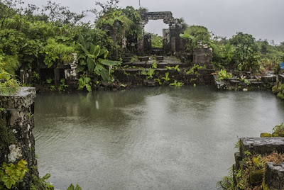
On the way back home, as the rains gave some break, we stopped over an extremely beautiful ancient temple - Kukadeshwar. This is the place where Kukadi River originates – the river which near
Nighoj forms the famous natural Pot-holes.
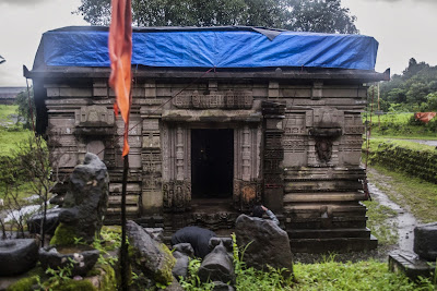 |
| Kukadeshwar Temple |
The temple is in ruined state. The villagers are organizing its reconstruction. The work is under progress.
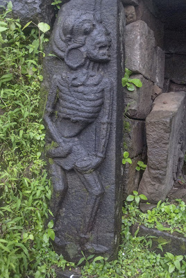 |
"Alien-like' Sculpture which seems to be
of a frail, old Lady |
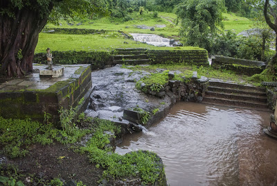 |
| Kukadi River |
Route from Pune:
Zoomed map of the Region:


